Istanbul, straddling two continents, is not just a city of unparalleled historical and cultural wealth but also one that lives in the shadow of a significant seismic threat. The North Anatolian Fault (NAF), a major source of earthquakes in the region, skirts to the south and east of this vibrant metropolis, placing it at a heightened risk of seismic activity. But in a city so vast, the question arises: which district of Istanbul will bear the brunt of such an inevitable shake?
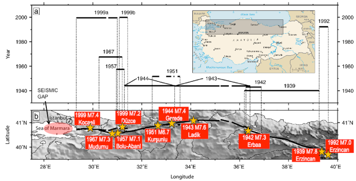
The sequence of westerly propagating ten large (M>6.7) earthquakes on the North Anatolian Fault Zone and the seismic gap in the Sea of Marmara close to Istanbul is an indication of a large earthquake.

The Epicenter of Concern: The Riskiest Districts
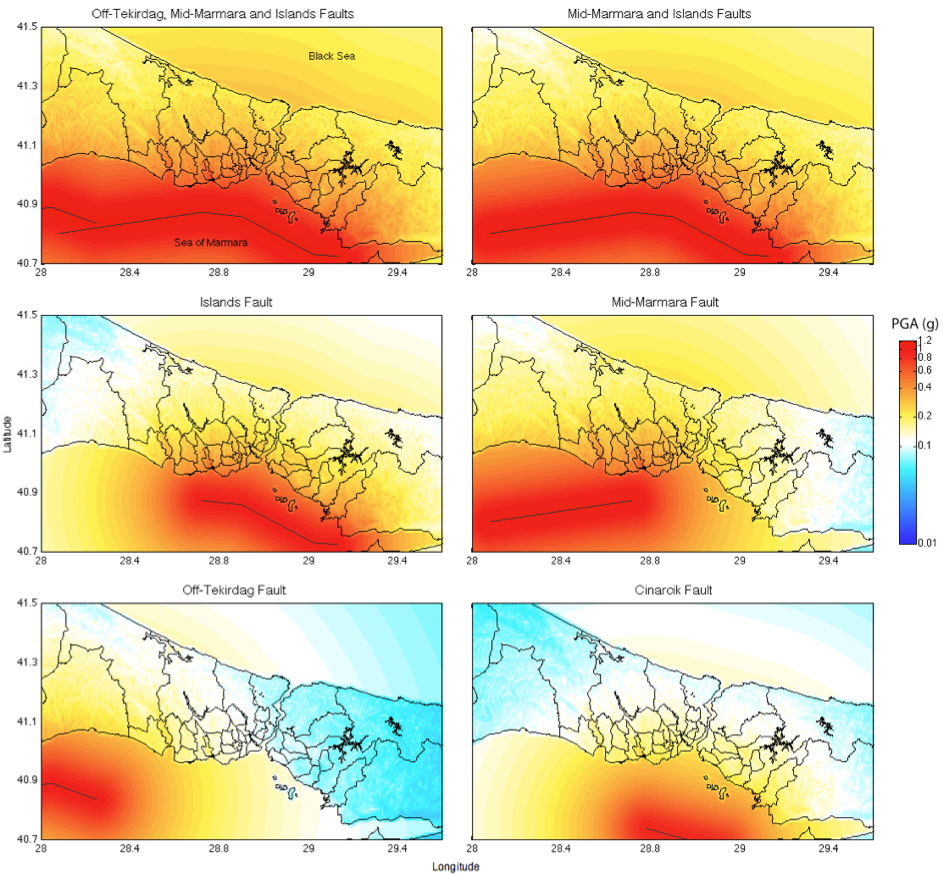
Historical data and seismic studies indicate that the districts closest to the North Anatolian Fault zone beneath the Marmara Sea, especially those on the city’s European side, are more vulnerable. Our most recent study (Kalkan and Gulkan, 2024) indicates that Istanbul’s western shoreline faces heightened risk, with median spectral accelerations at 0.3 s approaching 1 g, signifying intense shaking potential. Among these, Adalar, Bakırköy, Avcılar, and Zeytinburnu stand out as areas that might experience the most intense shaking. These districts, with their dense populations and structures, many of which were built before modern seismic standards were implemented, could face significant impacts in the event of a major earthquake.

The figure above shows close-up to peak ground acceleration (PGA) estimates for the Istanbul metropolitan area considering six earthquake scenarios. The median computed PGA is 0.65 g along the shoreline to the west of Istanbul (Bakırkoy district) and at Marmara Islands (Adalar district) as a result of multiple rupturing of Off-Tekirdağ, Mid-Marmara, and Islands faults.
The Science of Shaking: Understanding the Risk
Seismic risk is not only about proximity to the fault line but also about the ground beneath. Areas built on softer, sedimentary layers, such as parts of Avcilar, Atakoy, and Bakırköy amplify seismic waves, leading to more intense shaking compared to those on more solid rock. This geological variability across Istanbul means that the impact of an earthquake can differ dramatically, even within short distances.
Preparedness: The Key to Resilience
While the threat is significant, the focus now is on resilience and preparedness. Istanbul’s government and various organizations are working tirelessly to retrofit vulnerable buildings, improve emergency response systems, and educate the public about earthquake preparedness. Efforts are particularly concentrated in the high-risk districts, aiming to minimize the impact when the inevitable occurs.
Conclusion: A City Bracing for Its Future
As Istanbul faces its seismic future, understanding the areas at greatest risk is crucial for safeguarding its residents and heritage. While many districts along its shoreline may be more vulnerable, city-wide efforts to enhance resilience are a testament to Istanbul’s determination to protect its people and preserve its legacy against the forces of nature.
Engage with Us
Are you from Istanbul or have experiences related to earthquakes in the city? Reach us at info@quakelogic.net

